Hiking in Romania beyond Brașov and the Bucegi
Seven walks further afield: a volcanic crater lake, two limestone gorges, the Făgăraș ridge and the waterfall with the longest free fall in Romania, with travel times from Bucharest.
Most visitors to Romania hike in the Bucegi or Piatra Craiului, because those are the mountains you can see from the Brașov train. They are not the only ones.
At a glance — 7 walks
- Lacul Sfânta Ana, from Băile Tușnad
15 km · 849 m ascent · Easy to moderate · 4–6 hours - Cheile Turzii
5 km · Easy to medium · 2–3 hours · 4 lei entry - Cascada Vânturătoarea
1.5 km · 400 m ascent · Medium · 1.5 hours up - Ceahlău: Cabana Dochia and Vârful Toaca
5.2 km · 955 m ascent · 3 hours to the hut - The Buila-Vânturarița ridge
17 km · Hard · 10 hours · summer only - Cheile Râmețului and Brâna Caprei
5–6 hours · Difficult - The Făgăraș ridge
93 km · ~5500 m ascent · Multi-day
This page covers the rest: a volcanic crater lake in the east, limestone gorges you wade through in the west, the highest ridge in the country, and a waterfall you can walk behind. None of these are day trips from Bucharest — each involves a longer journey than the Brașov-area walks.
How far is far
Romania is bigger than it looks on a map and the roads are slower than the distances suggest. Rough travel times from Bucharest, by car unless noted:
- Băile Tușnad — 4 hours, or just under 4 by train from Gara de Nord. An hour from Brașov.
- Buila-Vânturarița — around 3–4 hours, into Vâlcea county.
- The Făgăraș ridge — the eastern end at Plaiul Foii is reachable via Zărnești; the western end is near Sibiu.
- Ceahlău — about 7 hours. This one is a weekend, not a day.
- Cheile Turzii and Cheile Râmețului — Transylvania proper, near Turda and Alba. Fly to Cluj instead.
- Cascada Vânturătoarea — the far south-west, near Băile Herculane.
The walks
Lacul Sfânta Ana, from Băile Tușnad
15 km · 849 m ascent · Easy to moderate · 4–6 hours
Train to Băile Tușnad; the circuit starts in the town.
Romania's only volcanic crater lake, on a 15 km loop out of a small spa town on the Olt. The most accessible of these without a car: you arrive by train, sleep in the town, and the circuit starts there.
Cheile Turzii
5 km · Easy to medium · 2–3 hours · 4 lei entry
12 km from Turda. Free parking, which fills early at weekends.
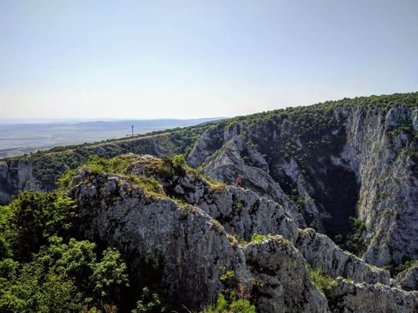
A limestone gorge protected since 1938, with steel cables and bridges along the streambed and a steep climb onto the rim. Short and busy; the car park fills early.
Cascada Vânturătoarea
1.5 km · 400 m ascent · Medium · 1.5 hours up
Park at the end of the Prisaca reservoir, 15 km from Băile Herculane.
Fifty metres over two tiers, with a 40-metre free fall — the longest in Romania. The wall behind is overhung, so you can walk behind the water without getting wet. Short but demanding, and watch for vipers.
The full route description, with more photos and a GPS track, is on greuladeal.ro (in Romanian).
Ceahlău: Cabana Dochia and Vârful Toaca
5.2 km · 955 m ascent · 3 hours to the hut
Drive to Cabana Izvorul Muntelui. No easy public transport answer.
The holy mountain of Moldavia, standing alone well away from the Carpathian spine. Sleep at Dochia and take the 45-minute red stripe to the 1904 m summit in the morning.
The Buila-Vânturarița ridge
17 km · Hard · 10 hours · summer only
Cabana Cheia by car, but you need 20 cm of ground clearance.
A limestone crest in the Căpățânii mountains, little visited by foreign walkers. The ridge section is exposed and deliberately not fitted with chains — you climb on rock, roots and dwarf pine. Read the guide before you commit.
Cheile Râmețului and Brâna Caprei
5–6 hours · Difficult
Cabana Râmeț, in the Trascău mountains. Not on Google Maps — use Mapy.cz.
Up an exposed ledge on cables, through a village, then back down the gorge wading the stream — the only way to see it properly. Water shoes are worth bringing; we did it in hiking boots.
The Făgăraș ridge
93 km · ~5500 m ascent · Multi-day
Part of the E8 path, which runs from Cork to Bulgaria.
Romania’s highest mountains, and a serious undertaking: no easy exits in the middle, basic refuges, unreliable water. The waymarked line contours around most summits, so standing on Moldoveanu means leaving it and coming back.
Before you go anywhere on this page
- Mountain rescue is Salvamont — dial 112, or their direct dispatch on 0725 826 668 (it spells 0-SALVAMONT on a keypad). The rescue itself is free; your treatment and evacuation are not, so bring insurance that covers hiking.
- Shepherd dogs guard flocks on open ground all summer and will run at you barking. Stop, don't run, don't turn your back, move away steadily and let the shepherd call them off.
- Cash. Cabanas and park entry points often don't take cards.
- Offline maps. Signal is unreliable and painted waymarks are the real navigation — a red stripe, a blue triangle, a yellow cross.
- Winter is a different sport here. Several of these are summer-only, and the ones that aren't need crampons, an axe and the experience to use them.
Closer to Brașov?
If you are based in the usual places, start with hiking near Brașov, hiking from Bușteni, or day hikes you can reach from Bucharest by train.